Where Are You From?
If you are of Teochew descent, you may have been asked where in Teochew your ancestors are from. You may have also noticed the names of the old counties in clan association publications, on old gravestones, and in descriptions of local dialects / regional pronunciations of the Teochew language.

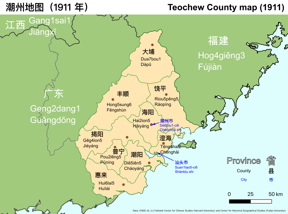
This map shows the counties within Teochew region around the end of the imperial period in 1911, along with their pronunciation in Teochew and Mandarin. Teochew was and is part of Guangdong Province, lying on the border with Fujian. In the present day, the region is divided into three city-level administrative units: Cháozhōu, Shàntóu, and Jiéyáng. Shàntóu City (Swatow, Suan1tao5) is the largest city and the economic center, even though Chaozhou City was formerly the administrative center. As a result, the Teochew region is also known as Cháoshàn (Diê5-Suan1) 潮汕 today.
Notice that the region is not very big. The scale bar on the map is 50 km, which is roughly the size of Singapore island from East to West. Nonetheless, in the pre-industrial era, this geographical distance was enough for Teochew people to develop their own language and culture, and even for there to be regional dialects within the Teochew language.
Traditionally, Teochew people speak of the eight districts (boih4ib4 八邑), even though there are nine shown on the map, as reflected in the name of the Teochew Poit Ip Huay Kuan clan association in Singapore. This is because the population of Dua7bou1 (Dàpǔ) district in the North is predominantly Hakka, even though for administrative purposes it was a part of Teochew region.
Ua2 si6 Diê5ziu1-nang5
我 是 潮州人。
I am a Teochew person.
Nang2 si7 ga1gi7-nang5
俺 是 家己人。
We (inclusive) are the same people. (i.e. “You are one of us”)
Read more on the Learn Teochew website
Sources: Mapping data is from the Chinese Historical GIS project (https://sites.fas.harvard.edu/~chgis/data/chgis/v6/). The map was drawn in the open source program QGIS (https://qgis.org/en/site/).
Posted on 2020-09-10 00:00:00 +0000